Daiyōsei, also known as Daiyōsei Archipelago, (大妖精群島, Daiyōsei Guntō) is a region consisted of 19 tropical islands. It was an autonomous region that had tried to be independent from HTFW. This region became de facto part of Shin Heian Prefecture. This is also the region where unusual weather phenomena took place that no one has ever witness nor science can accurately describe them.
Residents[]
- Brick (left the HTFW, former owner)
- Taisho (Current owner)
Visitors[]
Administrative Areas[]


Region[]
- Kanan (河南) Region (Consists of Hinomori and Kobinomori Islands)
- Kishō/Gisang (気象/기상) Region (Consists of East Tatsumaki and the surrounding islands)
- Keiki (京畿) Region (Consists of West Tatsumaki and the surrounding islands)
- Eirei/Yeongnyeong (映霊/영령) Region (Consists of Shinra-Bansho and the surrounding islands)
Designated Cities[]
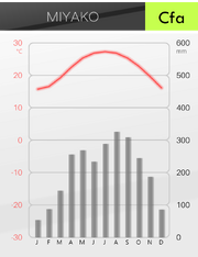
- Miyako (京) (Kanan Region), (Jeokgyeong / 적경 / 赤京 in Korean)
- Kazedori (風鳥) (Keiki Region) (Pungjo (풍조))
- Sabaku (沙漠) (Eirei Region) (Samak (사막))
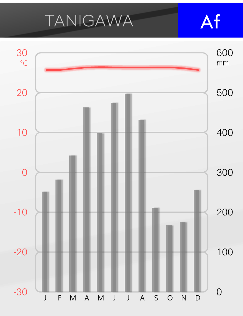
- Tanigawa (谷川) (Kishō Region) (Gokcheon (곡천))
Prefectures and Cities[]
- Kanan Region
- A1: Nankei (南京)
- Capital: Miyako (京) (Historical Japanese: Sekkyō (
赤京 ); Korean: Jeokgyeong (赤京 ))
- Capital: Miyako (京) (Historical Japanese: Sekkyō (
- A2: Nakamura (中村)
- Capital: Eisen (
永川 ) / (Yeongcheon(永川 ) in Korean)
- Capital: Eisen (
- A3: Izayoi (十六夜)
- Capital: Sakuya (
咲夜 ) / (Soya(咲夜 ) in Korean) - Significant Cities: Man'yō (万葉)
- Capital: Sakuya (
- A4: Seiryū (青竜)
- Capital: Shinju (真珠)
- A5: Naruto (鳴門)
- Capital: Umitsubame (
海燕 ) (Historical Japanese: Kaien (海燕 ); Korean: Haeyeon; Chinese: Haiyan)
- Capital: Umitsubame (
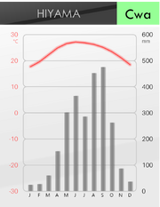
- A6: Hiyama (日山)
- Capital: Hiyama-Takayama (
日山高山 ) / (Ilsangosan(日山高山 ) in Korean)
- Capital: Hiyama-Takayama (
- A7: Fuzuki (不月)
- Capital: Veliky Novgorod/Velykyi Novhorod/Daishinchō (Великий Новгород/大新町)
- A8: Akayama (赤山)
- Capital: Kanmuri (かんむり)
- A9: Mugen (無限)
- Capital: Soya (
祖矢 )
- Capital: Soya (
- A10: Yamato (大和)
- Capital: Himeyama (姫山)
- A11: Gradius (グラディウス)
- Capital: Soinochi (生命) / (Saengmyeong(생명) in Korean)
- A12: Kuroishi (黒石)
- Capital: Hanamura (花村)
- A13: Shiraishi (白石)
- Capital: Teikō (帝光)
- A1: Nankei (南京)
- Keiki Region
- B1: Midoriya (緑谷)
- Capital: Zelenivka/Hisui (Зеленівка/翡翠)
- B2: Onshi (恩施)
- Capital: Waichū (淮中)
- B3: Saishū (済州)
- Capital: Iraijō/Wiryeseong (慰礼城/위례성)
- B4: Taiden (大伝)
- Capital: Dyvoptakhovka/Kazedori (Дивоптаховка/風鳥)
- B5: Seien (清遠)
- Capital: Neikoku (寧国)
- B6: Kamikaze (神風)
- Capital: Shin Zenra/Sin Jeolla (新全羅/신전라)
- B7: Sukuna (少名)
- Capital: Kameshiro (亀城)
- B8: Ikai (異界)
- Capital: Mugetsu (無月) / (Muwol(무월) in Korean)
- B9: Kierke (キルケ)
- Capital: Tenmachō (天馬塚)
- B1: Midoriya (緑谷)
- Kisho Region
- C1: Denkō (湛江)
- Capital: Shirogane (白金)
- C2: Senbi (汕尾)
- Capital: Tanigawa (谷川)
- C3; Nishiya (西屋)
- Capital: Amizaki/Naseon (羅先/나선)
- C4: Tsukigawa (月川)
- Capital: Kokoro (こころ)
- C5: Denshi (電子)
- Capital: Saigen (済源)
- C6: Aogitsune (青狐)
- Capital: Kyūbi (九尾)
- C7: Tekkyō (鉄橋)
- Capital: Hakkakukei (八角形)
- C8: Kōchakushi (膠着子)
- Capital: Buketsu (武穴)
- C9: Shinomori (篠森)
- Capital: Hō'ōma (鳳凰松)
- C10: Yogawa (四川)
- Capital: Onderon (音出論)
- C11: Chūrin (中林)
- Capital: Kanemoto (金本) / (Geumbon(금본) in Korean)
- C12: Fumigawa (文川)
- Capital: Fuyo/Buyeo (扶余/부여)
- C13: Iōzan (硫黄山)
- Capital: Irokuni/Saekguk (色国/색국)
- C14: Tanishima (谷島)
- Capital: Hanamotomi (花盛頓)
- C15: Kaguya (赫映)
- Capital: Eian (永安)
- C16: Urashima (浦島)
- Capital: Toshimura (年村)
- C17: Tenkai (天界)
- Capital: Eisho (永暑) / (Yeongseo(영서) in Korean)
- C1: Denkō (湛江)
- Eirei Region
- D1: Zuishū (随州)
- Capital: Sabaku (沙漠)
- D2: Seiren-sei (性連西)
- Capital: Hōzan (鳳山)
- D3: Seiren-chū (性連中)
- Capital: Nagame (眺目) / (Jomok(조목) in Korean)
- D4: Seiren-tō (性連東)
- Capital: Ryūkyū/Yugu (琉球/유구)
- D5: Higashinoshima (東之島)
- Capital: Higashimura (東村) / (Dongchon(동촌) in Korean)
- D6: Akagitsune (赤狐)
- Capital: Utsuo (打尾)
- D7: Suzu (珠洲)
- Capital: New Tagaytay/Kirunori (切父) / (Jeolbu(절부) in Korean)
- D8: Ryūsei (流星)
- Capital: Hoshino (星野)
- D9: Enrei (炎霊)
- Capital: Kaian (海安)
- D10: Styx (ステュクス)
- Capital: Mima (未間)
- D1: Zuishū (随州)
Houses and Apartments[]
WIP
Buildings[]
Tekkyō[]
- Docm Thunder Tower
Areas[]
WIP
National parks and mountain ranges[]
- The 19 Islands (十九島, Jūkyū-Shima)
- Hinomori Island (日野森島)
- Kobinomori Island (小日野森島)
- Mizutani Island (水谷島) (The smaller of the Tani Islands south of Tatsumaki Island)
- Soratani Island (空谷島) (The larger of the Tani Islands)
- Tatsumaki Island (竜巻島)
- Daitekkyō Island (大鉄橋島)
- Shōtekkyō Island (小鉄橋島)
- Shinra-Banshō Island (森羅万象島)
- Kazan-Nan Islands (火山南諸島) (the 4 Islands south of Shinra-Bansho Island)
- Shōwa Island (昭和島) (a small island north of Shinra-Bansho Island)
- Hōraisan Islands (蓬莱山諸島) (the 3 Islands southwest of Tatsumaki Island)
- Nishiyama Island (西山島)
- Shinmyōmaru Island (針妙丸島) (West of Nishiyama Island)
- Tensai Island (天才島) (North of Tatsumaki Island)
- Bōrei Desert (亡霊砂漠) (Located at Shinra-Banshō Island within Eirei Region)
- Yūrei Ocean (幽霊洋) (Located north of Kanan Region)
- Temeekunga/Temikyūga Sea (天実球花海) (Surrounded by Keiki and Kishō Regions)
Transportations[]
WIP
Climates[]


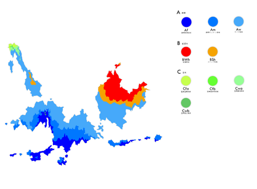
Because the entire region is located near the equator, most of Daiyosei experience tropical climates. And the number of seasons varies depending on the influence of Trade Wind II. The northernmost part of the Kanan region has warm to cool winter because of the subtropical low pressure passing by the ocean above Kanan region. The high pressure generated by heavy descending air get locked above the northern part of Eirei region. What that does is making these specific areas into deserts.
Highest temp recorded: 50.7°C (Zuishu, 2011)
Lowest temp recorded: 5.2°C (Nakamura, 2014)
Af (Tropical Rainforest)[]
These areas always experience hot and wet conditions by the Trade Wind II above.

Am (Tropical Monsoon)[]
By the indirect influence of the subtropical high pressure, these areas experience drier seasons which are relatively dry, but still humid enough to be classified to this climate type.


Aw (Tropical Savannah)[]
These areas experience very clear wet & dry condition due to the pressure change by the axial tilt of the planet.


BWh (Hot Desert)[]
These areas experience further heating and very little rain caused by the subtropical high pressure above.


BSh (Hot Semi-arid)[]
These areas also get influenced by the subtropical high pressure. Unlike BWh areas, the Trade Wind II still penetrates these zones, bringing the humidity enough to form steppe biomes.


Cfa (Humid Subtropical)[]
These areas are located in the northernmost coastline of the Kanan region. Due to the temperate low air column above, these areas experience somewhat milder or cooler temperature in winter.

Cwa (Subtropical Monsoon)[]
These areas experience hot and wet summer and warmer and dry winter due to the monsoon wind from the ocean nearby and remaining dry air flow from the subtropical low pressure.

Cwb (Subtropical Highland)[]
These areas experience cooler but still warm summer by being at high altitude.


Cfb (Subtropical Highland)[]
Unlike the oceanic areas in Shin Heian and Tesserasteria, these areas are highlands near the equator, normally experiencing mild temperature and frequent rain all year-round. Due to the orographic lifting phenomenon, most of these areas also experience very intense rainfall. In fact, Kazedori is the wettest region in Daiyosei.


Translations[]
| Language | Translation |
|---|---|
| Korean | 대요정 (Daeyojeong, lit Daiyōsei) |
Trivia[]
- This archipelago was originally named Morassa.
- The names of Miyako were based on the Kun'yomi pronunciation of a specific Kanji, 京.
- Kōchakushi (The Japanese name for Gluon) is named in parallel to Jungseongjaseong (Korean name for Neutron Star) in line with the existence of Quark-Gluon Plasma, which is a possible component of a star remnant.